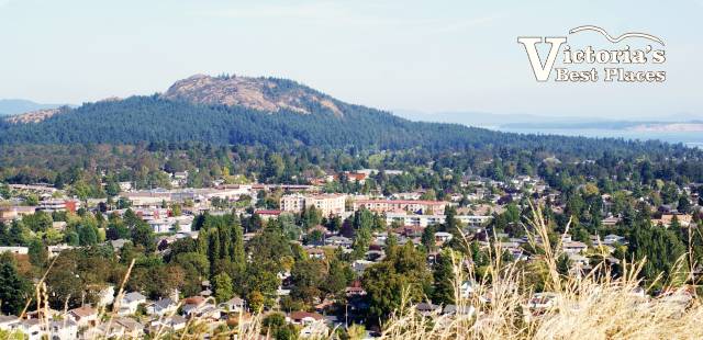
Mount Douglas Park is a mountain and forested park near Victoria’s Gordon Head neighbourhood. It features hiking trails, a rocky beach and beautiful views.
(NOTE: In the summer of 2022 Saanich Municipal Council approved a request by local First Nations to rename Mount Doug to PKOLS which is the mountain’s original, Indigenous name. In the local SENĆOŦEN language, the name PKOLS means “White Rock.” Although still called Mount Doug by many, out of habit, its new official name is PKOLS. The change was done in recognition for the need for reconciliation and in honour of the mountain’s cultural and historical significance to the local W̱SÁNEĆ people throughout history. PKOLS is pronounced “P’cawls”.)
This article contains information about the following topics:
Where is Mount Douglas | About Mount Douglas | The Mountain Peak | Hiking Trails | Beach | Tips and Advice | Other Information
PKOLS (Mount Douglas) Park
Commonly referred to as Mount Doug, but now PKOLS, this park has hiking trails to explore, beautiful lookouts and a beach. From the top you can see the entire Greater Victoria area and in the distance is the Olympic Mountain range in Washington state.
Mount Doug Park has many reasons why people go there but arguably the main ones are its hiking trails and views. With over 20 kilometres of trails, there are different levels for a variety of hikers.
If you want to see a birds-eye view of Greater Victoria and the Saanich Peninsula, hike to the top of Mount Doug Park and have a look around. The scenery from the peak is spectacular. There are also more trails to explore at the top.
Many roads go through Mount Douglas Park including Cedar Hill Road, Cordova Bay Road and Ash Road. To get to the summit you drive up Churchill Drive, which is off Cedar Hill Road. The road access gates are closed daily until noon (and all day on long weekends), so you’ll have to plan ahead to admire the beautiful views in your vehicle.
Where is Mount Douglas/PKOLS
PKOLS/Mount Doug is located in the municipality of Saanich at the edge of Cordova Bay which is a body of water along the eastern coast of Greater Victoria.
The mountain top is accessed by Churchill Drive which is located by the intersection of Shelbourne Street and Cedar Hill Road. Mount Douglas Beach is at the northeast edge of the park at 4550 Cordova Bay Road. (Note: The road up does not open until 12:00 pm daily. It is also sometimes closed completely for the entire day at peak times including holiday weekends.)

About Mount Douglas
Mount Doug Park is close to 188 hectares or 1.88 square kilometres in size and the mountain peak is about 213 metres or 710 feet high. It’s fairly big for an urban mountain and can be seen from far away. From the top, it offers 360-degree views of the region.
Established in 1858, the park is comprised primarily of dense forest and features 21 kilometres of hiking trails, a rocky shoreline that includes Mount Douglas Beach, and a mountain peak with spectacular views that are occasionally accessible by car.

The Mountain Peak
Mount Doug is famous for its views from the top. Many people hike to the peak, but many also drive up, park in the small parking lot, and then walk the final short distance at a leisurely pace.
There is a wheelchair-accessible lookout area right at the parking lot near the top of the mountain with fabulous views of the surrounding area. From the parking lot there are also two trails that take you a short distance even further up the hill. The trails themselves are uphill and over rocky terrain, so they are not accessible to people with mobility issues.
At the top of the mountain, in one direction there is a fairly easy gravel walking trail that most people can easily manage, although not with wheelchairs or walkers. People do manage to go up with sturdy strollers.
In the other direction the trail is also quite manageable, but a bit more of a rugged climb, especially at the start over the rocks. However, once you’re over the initial rock, exploring the rest of the way is relatively simple.

Mount Douglas Hiking Trails
There are a variety of trails in Mount Doug Park. At the base of the park there is a map that outlines the various trails and their levels of difficulty. Green means easy, blue means medium and black means difficult. There are markers along the trail that tell you how high above sea level you are and how many metres until you reach the summit.
When hiking the trails, it’s easy to get confused or end up on another trail. If you want to hike a specific trail without veering off it, make sure you diligently follow the signs and maybe use a GPS.
There are a number of things that the park asks of those wishing to hike in it including the following:
- Appreciate the plants and nature around you and don’t harm anything.
- Don’t leave litter (or anything) in the park.
- Dogs must be under control. Although, they’re allowed off-leash they must be calm and not destroy the nature near the paths.
- Bicycles aren’t allowed on the trails. They are permitted on the road up to the summit (but it’s a long ride up).

Mount Douglas Beach
Mount Douglas Beach is a small rocky piece of shoreline at the northeast corner of Mount Doug Park. There is a large parking area at the entrance and from there a short but slightly steep walk down to the water. Near the parking lot there is also a children’s playground.
There is a bit of sand at the beach, but it’s mostly rocky and rugged. Don’t expect to see people swimming, but do expect washed up logs at the high tide line, occasional marine life, and beautiful views on sunny days.
Tips & Advice
Below are some tips and useful bits of information to help you make the most of your visit to Mount Doug Park.
Things To Know Before You Go
TIP #1: The sunsets from the top of Mount Doug are spectacular. Bring your camera for the 360-degree views!
TIP #2: If planning to drive up to the top of the mountain, go after 12:00 pm. Because of the park’s popularity and in an effort to encourage cycling, Churchill Drive is closed to traffic until noon seven days a week. If you arrive early and find it’s closed, (1) park at the bottom and get some exercise walking up, (2) come back later after lunch during the road’s opening times or (3) go to Mount Douglas Beach and explore that area for a while first.
TIP #3: The best time to go to the beach at Mount Doug is on a sunny day at low tide. On a clear day, from Mount Douglas Beach you can see snow-covered Mt. Baker across the water in Washington state. Also, at low tide there’s more to explore.
TIP #4: Mount Doug is a popular place, but the parking area at the top isn’t big. The odds of finding a parking spot are usually pretty good, but less so on weekends and in the summer.
Other Things To Know
TIP #1: The short treks to the peak of the mountain from the top parking lot are highly recommended and manageable by most people, young and old. There are multiple rocks from which to admire the stunning views, but there are also steep slopes and cliffs.
TIP #2: The top of Mount Doug is a wonderful place for children to explore and have fun. Keep a close eye on young folks though and don’t let them get too close to the edges. Good sturdy walking shoes are also recommended.
TIP #3: The views from the top are worth the effort to see them and the hike from the bottom to the top is about 1.5 kilometres – all uphill. We hiked a black trail to the top, and it was truly a difficult route. If you aren’t comfortable with a little exertion you can find an easier green or blue trek to the top.
TIP #4: If you plan to walk between the beach and the trails to the top of the mountain, make sure you use the pedestrian crosswalks.
Other Information
For more information on the park, click Mount Doug, and for a map of the area click Mount Doug Map.
Other articles that might be of interest include the following:
For the next time you visit Vancouver and the Lower Mainland, other articles you might be interested in include the following:
- Lower Mainland Parks and Nature
- Vancouver’s Top 100 Places
- The A to Z’s of Vancouver
- Lower Mainland Hiking Trails


